


Tracegps.com Issued - Tour de coeur du var

Doubotis
User ADMIN
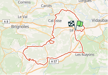

Length
93 km

Max alt
442 m

Uphill gradient
1312 m
Km-Effort
111 km

Min alt
95 m

Downhill gradient
1310 m
Boucle
Yes
Creation date :
2021-04-02 08:06:17.39
Updated on :
2021-06-02 07:22:17.197

FREE GPS app for hiking
 SityTrail
IGN / Geographical institutes
SityTrail Plus
The world is yours!
About
Trail of 93 km to be discovered at Provence-Alpes-Côte d'Azur, Var, Le Luc. This trail is proposed by Doubotis.
Positioning
Country:
France
Region :
Provence-Alpes-Côte d'Azur
Department/Province :
Var
Municipality :
Le Luc
Location:
Unknown
Start:(Dec)
Start:(UTM)
282684 ; 4807921 (32T) N.
Comments
test